National parks of the Canary Islands
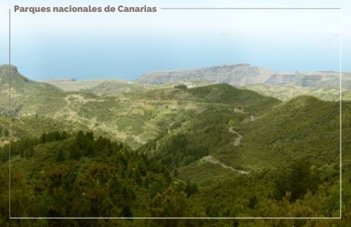
The Canary Islands are the Spanish region with the largest number of national parks in the whole country. In addition, this area has one of the most valuable ecosystems in the world, so much of this archipelago is listed as a protected natural area, in which 4 of the 15 national parks of Spain are located.
One of the most privileged destinations in the world are the Canary Islands, an area full of diversity, with natural environments of great beauty, beautiful and surprising landscapes that include both beaches and mountains.
The archipelago has 546 exclusive plants and 141 protected areas,making it an excellent place to visit. Of these protected areas, four are national parks, stay with us and know in detail each of these wonderful natural spaces, as well as the geography of these islands.

Geography of the Canary Islands
The Canary Islands is a group of archipelagos that are located in the Atlantic Ocean. It is located near the coast of Africa, specifically in front of Morocco and Western Sahara. Due to its geographical position, it has a border character and is a place of passage in navigation between Europe, Africa and America
This archipelago of volcanic origin is made up of 7 islands, which are:
- Gran Canaria
- Tenerife
- The Palm
- Iron
- Lanzarote
- Fuerteventura
- La Gomera
In addition, it has six smaller islands (La Graciosa, Alegranza, Montaña Clara, Lobos, Roque del Este and Roque del Oeste).
The total area of the Canary Islands is 7,446 km² and is located between latitudes 27º 37' and 29º 25' north and longitudes 13º 20' and 18º 10'.
Timanfaya National Park
The Timanfaya National Park is located on the island of Lanzarote, was declared a Biosphere Reserve by UNESCO in 1993. It is considered a practically virgin area, with very little intervention by the hand of man, in which beautiful and amazing natural landscapes are appreciated.
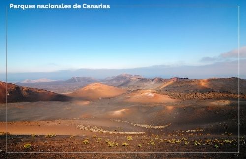
It is a territory of volcanic origin that resulted from the volcanic eruptions that occurred between the years 1720, 1736 and 1824; with more than 5,000 hectares, in which there are 25 volcanoes with immense beauty, in which you can make tours on foot, by bus or on camel rides. The last eruptions of these volcanoes took place in 1824.
It is important to note that in this park the mineral world predominates. Its authentic countries, rock formations and colorful sand layers make it an excellent destination, both for Spaniards and tourists from other countries.
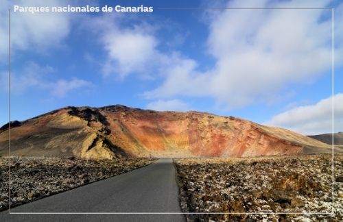
It offers several options to visitors, where they can enjoy its wonderful landscapes and fully enter the volcanic world.
It has a rather difficult climate, so both animal and plant life is very scarce, however, it is the habitat of several endemic species, both animal (the Haria Lizard) and plants (El Bejeque or the Botón de Lanzarote or the Tabaiba). In addition, because it is an area that still has volcanic activity, you can feel the heat that is released in some parts of the surface.
El Teide National Park
Mount Teide is the most visited national park in Spain, and even one of the most visited in the world, and is located on the island of Tenerife. It is the first park that was created in the Canary Islands, specifically on January 22, 1954 and has an area of 18,990 hectares.
It is one of the best destinations for nature lovers, since this park houses the third highest volcano on the planet, and the highest point in all of Spain with 3718 meters above the level, and we refer to the Teide Volcano, which had its last eruption in 1798. Without a doubt a geological wonder that you must visit.
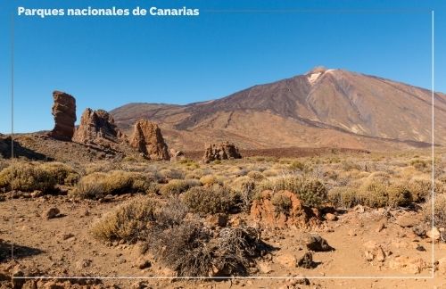
You can access the Teide volcano through a 6-hour tour, in which you will observe beautiful trails and a wonderful view. In addition, you have the option of doing it in a cable car whose route is only 8 minutes, with beautiful landscapes where you can appreciate the whole island, and even depending on the weather you can reach to see other islands of the archipelago.
In addition, in this national park we also find the Pico Viejo, which has a crater about 100 meters deep.
It was declared a World Heritage Site by UNESCO in 2007. This national park of the Canary Islands is the habitat of several endemic species of Canarian flora and fauna, which can withstand the climatic conditions of the area.
Mount Teide is also a territory with important archaeological sites of the Guanches, known as the first settlers of the Canary Islands. Without a doubt a wonderful place, with impressive landscapes, diverse contrasts and a great geological value that you should not miss.
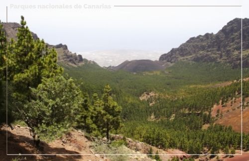
Garajonay National Park
The Garajonay National Park represents the most wonderful landscapes of the island of La Gomera, with a great richness both animal and vegetable, being one of the most important forests today. In 1981 it was declared a national park, being the last and most recent of the Canary Islands. In addition, in 1986 it was declared a World Heritage Site by UNESCO.
The name of this park is due to the romantic aboriginal legend of Gara and Jonay, who threw themselves from the top of the mountain for love. It has an area of almost 4,000 hectares, and its territory covers all the municipalities of La Gomera.
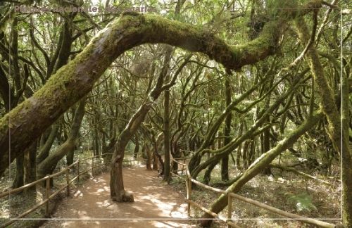
It is one of the few remaining laurel forests in the world, which is always shrouded in fog. In this original ecosystem you can appreciate an extensive variety of natural nuances, environments and reliefs, with up to seven different types of vegetation.
Garajonay is undoubtedly a magical place, with wonderful trails, extraordinary millenary trees and varied vegetation in which mosses, lichens and ferns stand out. In addition, it houses various endemic species and spectacular geological monuments. Without a doubt a very visited national park, ideal for nature lovers.
La Caldera de Taburiente National Park
The National Park of La Caldera de Taburiente was created thanks to a volcanic crater on the Island of La Palma. It stands out among other areas of volcanic origin for the large amount of water resources it has, both on the surface and below the earth.
It is a national park since 1954, it houses a very varied vegetation, with endemic species of the Canary Islands both in flora and fauna. It has an approximate diameter of approximately 8 km and a kilometer and a half of depth.
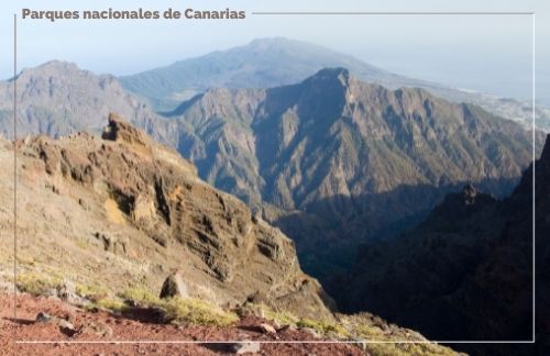
The Caldera de Taburiente you will be able to appreciate lush forests of Canarian pine, wonderful landscapes, spectacular waterfalls, rivers, waterfalls and deep ravines that will surprise you. Despite being the least visited of the 4 national parks of the Canary Islands, it has a lot to offer those who choose this destination.
In addition, in this park there are abundant archaeological remains, mainly rock engravings, which are known as petroglyphs. One of the most striking geological formations in the park are the Roques, stone monoliths that resist erosion. Which were also places of worship of the ancient inhabitants of the island.
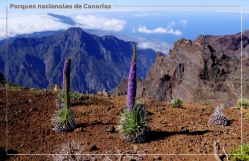
One of the greatest riches of the Caldera de Taburiente is the water, with more than 70 springs that are very well used by its inhabitants.